

forest [Desktop Wallpaper HD] |
Archive for March 3, 2012
 bamboo [Desktop Wallpaper HD] bamboo [Desktop Wallpaper HD] |
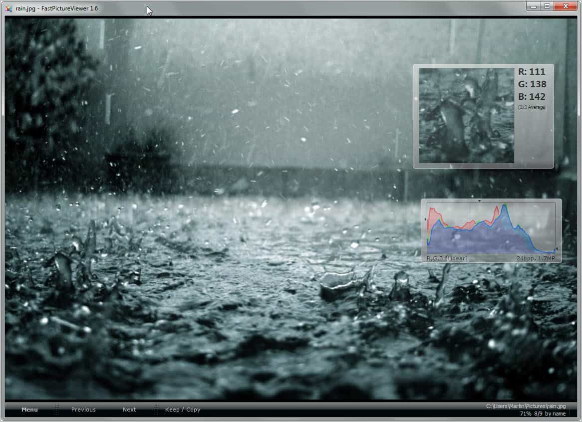
| FastPictureViewer Professional has always been a part of the Christmas Giveaway here at Ghacks, and deservedly so. Back in 2008 when it was first released it was more of a fast but basic image viewer that was fully color managed. Today, the program is a full blown tool for professionals and enthusiasts that can “process files in batch (copy, move, rename, export, FTP upload, delete…), write IPTC metadata, write XMP rating, has histogram/EXIF gadgets, can tether digital cameras, play slideshows and supports its own RAW codecs in both 32-bit and 64-bit editions.
The program uses a modular approach giving the user the option to enable or disable modules during installation. The program interface has not changed that much over the years which becomes apparent if you look at previous reviews of the program here on Ghacks. But that is not necessarily a disadvantage as it worked and works quite well for the tasks it can be used for. FastPictureViewer Pro has three core audiences. Professional photographers, imaging professionals and photo enthusiasts. Photographers often have to quickly sift through a folder of photos that they have taken, and FastPictureViewer allows them to do just that. The application can be used to facilitate the first review pass that usually consists of culling or rating. The program uses software decoders provided by camera manufacturers to always stay on top when it comes to image format support. Additional features worth noting are intelligent preloading of images in memory for faster loading times, full color management and profiled monitor support, as well as plug and play tethered shooting (connecting the camera via USB to a computer or screen to display them in full screen automatically), Adobe XMP rating and Microsoft photo rating support, color-managed Raw previews and metadata support.
Speed and performance are important to all users, but especially so for imaging professionals. The program supports modern technologies such as multi-processing and multiple-cpu cores, hardware accelerated display adapters and advanced memory management. It sets new limits as far as image quantities and sizes go. FastPictureViewer Professional supports very large images, the developers have for instance tested it with a 466 Megapixel images taken by the Hubble Space Telescope. The program can be used to go through hundreds of thousands of images without noticeable drop in performance. The bookmark feature allows imaging professionals to save folder specific image bookmarks, for instance to mark interesting images or to save the current review location to continue going through the images at a later point in time. FastPictureViewer Professional’s support for XMP can be put to use to quickly add rating tags to images. This way images could receive accepted, undecided and rejected ratings with a single key stroke. What’s New in 2011 When you look at the modifications that Axel implemented in the last year, you will notice some high caliber additions. FastPictureviewer Professional now features a View Filter which can be used to restrict viewing to images of a specific rating or tag (e.g. only five-star photos or photos marked as undecided). The program’s GPS Metadata support has been improved. A photos GPS location can now be displayed on screen, and users have options to launch Google Maps, Bing Maps, Flickr or Panoramio. Photos can be sorted by GPS timestamps and GPS data can be used in the program’s batch file processing module. The new IPTC Metadata Editor plugin adds support to write IPTC fields within files or external XMP sidecars. Raw format support for new camera modiles have been added, as well as support for Photoshop PSD files and CGI formats. Useful Links Here is a selection of links that new users and prospect buyers may find useful. Verdict I’m an enthusiast when it comes to photography. I recently bought a new Canon EOS DSLR and use FastPictureViewer to quickly go through the photos that I have taken. While I could do the same with other image viewers, they usually come with delays in opening new photos. I leave most of the features of the program to professionals though who will make good use of the features. Continuous support by the program’s developer, Axel Rietschin, ensures that it stays cutting edge. Giveaway We have 20 FastPictureviewer Professional licenses to give away. Please leave a comment below to take part in the drawing. If you like, tell us a bit about why you’d like a license for the program. |
Microsoft confirms SkyDrive Desktop app; details Windows 8 integration
via LiveSide.net by Kip Kniskern on 2/20/12
![]() In a blog post on the Windows 8 blog, Omar Shahine and Mike Torres confirmed today what we told you this weekend about an upcoming SkyDrive app, and provides some detail about the upcoming Windows 8 Metro style app for SkyDrive (“an early version of which will be available at Consumer Preview”).
In a blog post on the Windows 8 blog, Omar Shahine and Mike Torres confirmed today what we told you this weekend about an upcoming SkyDrive app, and provides some detail about the upcoming Windows 8 Metro style app for SkyDrive (“an early version of which will be available at Consumer Preview”).
As we have been suspecting for some time, it looks like Windows Live Mesh is about to morph from being a standalone product to a feature of SkyDrive, something that we think makes lots of sense. Microsoft has set itself a lofty goal of becoming “the world’s hard drive” (emphasis ours):
Growing our infrastructure is one of many things we have been busy working on, but most important of these are our investments in sync and cloud scenarios for Windows 8, which will finally bring the DNA of SkyDrive and Mesh together into one service. Given our goal to be the world’s hard drive, we will need to continue to build out the service, and you can expect our pace of improvements to continue through 2012.
The post starts by detailing the new SkyDrive Metro style app, and its foundation of JavaScript, CSS, and HTML5:
To build a SkyDrive experience on WinRT, we took an approach that we expect many web developers will choose to take on Windows 8. We built the entire app using modern web technologies like JavaScript, CSS, and HTML5, and because of our recent updates to SkyDrive.com, we were able to use the same JSON APIs and JavaScript object model that the website uses. The only difference on Windows 8 is that we bind the results to modern controls that were built for touch. This is part of the reason it’s so fast, and the touch behavior works so well (and works on Windows on ARM too). Over time, we fully expect the Metro style app and SkyDrive.com to “converge” on functionality so there won’t be a question of which experience someone should use. When using Windows 8, the SkyDrive Metro style app will be the best way to browse and manage your SkyDrive.
It then goes on to acknowledge the Windows Desktop app (although there’s no mention of a Mac app, which we told you about this weekend):
Of course, there are people who will use older versions of Windows for a while, so SkyDrive on the desktop will also run on Windows Vista and Windows 7. If you want to make sure your files come with you to Windows 8 and you’re still running Windows 7, you’ll just put them in your SkyDrive folder. This makes it easier to upgrade to Windows 8 or make sure you can access your files across all of your PCs.
SkyDrive for the desktop will also provide the ability to sync up to your available quota of storage (and the ability to unlock more), along with unmatched performance on your PC. Oh, and we will also have support for uploading large files (up to 2GB) through Explorer, another big request from SkyDrive.com users over the years.
The SkyDrive app, as we told you, will have built in remote access (much like Windows Live Mesh does now), which Omar and Mike call the “Forgot something?” feature:
We’ve done special work to enable remote streaming of video, and we’ll treat photo albums on your remote PC exactly as we do photo albums in SkyDrive, with the same beautiful full-screen viewer. We realize this is more of an enthusiast feature, as most people won’t have an always-on PC at home, but for those who do, fetching files works like magic.
So, to quickly recap, it looks like we’re getting full SkyDrive integration in Windows 8 through a Metro style app, and 3rd party integration through charms and contracts, a new desktop app, ability to upload folders and large files, video streaming from your home computer from anywhere, hints of the paid storage we told you about, and much much more! Wow!
We’ll have a bit more to say about SkyDrive coming up soon, including a few more surprises. Stay tuned!
| A few weeks ago, it was a YouTube video of Eric Clapton’s isolated guitar from The Beatles’ While My Guitar Gently Weeps that blew people’s minds. Today, a clip of Kurt Cobain’s isolated vocals from Nirvana’s classic Smells Like Teen Spirit is having a similar impact.
When you click on the video above, don’t think something is wrong – it takes 38 seconds for Kurt’s singing to begin, and it’s well worth the wait. By turns childlike and demonic, aloof and impassioned, it’s a brilliant, one-of-a-kind performance – thrilling and haunting. Nirvana recorded Smells Like Teen Spirit with producer Butch Vig in May 1991 at Sound City Studios in Van Nuys, California. Vig has said that Cobain tracked his vocals in three takes – a generous amount, apparently, as four passes on anything were rare for the singer. It’s fascinating to hear the production techniques that Vig employed: Cobain’s singing in the verses appears to be a single lead vocal, while in the pre-choruses and choruses his voice is doubled. Issued to radio on 21 August 1991, Smells Like Teen Spirit was the first single off of Nirvana’s 30-million-selling album, Nevermind. Read more about Listen: Kurt Cobain’s isolated vocals on Smells Like Teen Spirit at MusicRadar.com |


 Ever since Wave 3, Windows Live have always had the ability to connect within various social services from across the web, most notably services such as Facebook, LinkedIn and Twitter. By connecting other social services and websites to Windows Live, depending on the connection, you’ll be able to do things like viewing and posting status updates directly to/from Windows Live, integrating the contact list (which automatically de-duplicates for you), or in Facebook’s case, access Facebook Chat from Windows Live. Ever since Wave 3, Windows Live have always had the ability to connect within various social services from across the web, most notably services such as Facebook, LinkedIn and Twitter. By connecting other social services and websites to Windows Live, depending on the connection, you’ll be able to do things like viewing and posting status updates directly to/from Windows Live, integrating the contact list (which automatically de-duplicates for you), or in Facebook’s case, access Facebook Chat from Windows Live.
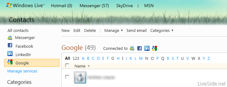
There are currently over 88 connected services from all across the world available on Windows Live. However, while YouTube and Blogger are available as a connected service, Google itself never made it onto the list. While you could always (meaning their contact details are copied over to as a Windows Live contact instead), this is different from having it exist as a connected service (where there is a link between Windows Live and Google, and any updates to the contacts on Google will be reflected in Windows Live periodically). We’ve recently noticed that this is changing, and Google is now finally available as a connected service to Windows Live:
At the moment, you can access your Google contacts from Messenger and Hotmail, and Windows Live will do the de-duplication for you in case you have the same contact on Messenger, Facebook or LinkedIn already:
However, the social aspects of Google+ are not available yet, so don’t expect your Google+ social feeds to start flowing into your Messenger Social or Windows Phone. This might set to change in the future, given that Microsoft is continuously expanding the connected service’s capability over time (for example, most recently with China’s micro-blogging service Sina Weibo). There was also a wild rumor that Google+ is coming to Windows Phone, although the validity of the source is questionable. You can connect Google to Windows Live now by clicking here. |

http://www.wired.com/wiredscience/2012/03/envisat-anniversary/?pid=3266&viewall=true
- By Betsy Mason
- Email Author
- March 2, 2012 |
- 7:09 pm |
- Categories: Earth Science

Ten years ago on March 1, the European Space Agency launched an 8-ton satellite called Envisat that would deliver back to Earth some of the most beautiful images of our planet taken from space.
Since then, Envisat has orbited Earth more than 50,000 times and has lived twice as long as planned.
The satellite has more than seven instruments on board that can use radar to see through clouds, capture ocean color and land cover, monitor the ozone layer and atmospheric pollutants, measure thermal-infrared radiation, and register surface topography.
To celebrate the satellite’s 10th anniversary, we’ve selected a few of its most beautiful images for this gallery. Good luck deciding which one to use as wallpaper for your computer desktop.
Above:
Von Karmen Vortices
This false-color Envisat image, acquired on June 6, 2010, highlights a unique cloud formation south of the Canary Island archipelago, some 95 km from the northwest coast of Africa (right) in the Atlantic Ocean. Seven larger islands and a few smaller ones make up the Canaries; the larger islands are (left to right): El Hierro, La Palma, La Gomera, Tenerife, Gran Canaria, Fuerteventura and Lanzarote.
Image and caption: ESA

Northwest Passage
Envisat ASAR image of the McClure Strait in the Canadian Arctic Archipelago, acquired on Aug. 31, 2007. The McClure Strait is the most direct route of the Northwest Passage and has been fully open since early August 2007.
Image and caption: ESA

Algerian Sahara
Envisat radar image of the Tanezrouft Basin in the Algerian Sahara. Radar images reveal surface roughness – the rougher the surface, the brighter it appears. Hence, darker areas represent softer rock with a sandy or small-stoned surface. This image was created by combining three Envisat radar passes (March 23, 2009, June 1, 2009 and Sep. 14, 2009) over the same area. The colors result from changes in the surface between acquisitions.
Image and caption: ESA

Galapagos Islands
This Envisat image features the Galapagos Islands, an archipelago situated some 1,000 km to the west of Ecuador in the Pacific Ocean. Galapagos’s largest island is Isabela (visible). The five volcanoes seen on the island are (from north to south): Wolf Volcano, Darwin Volcano, Alcedo Volcano, Sierra Negra Volcano and Cerro Azul Volcano. The bigger island to the right of Isabela is Santiago Island.
The image was obtained by combining three Advanced Synthetic Aperture Radar (ASAR) acquisitions (March 23, 2006, Aug. 14, 2008 and Jan. 1, 2009) taken over the same area. The colors in the image result from variations in the surface that occurred between acquisitions. Apart from mapping changes on the land surface, radar data can also be used to determine sea surface parameters like wind speed, wind direction and wave height. Different wave types and wind speeds are visible in the image as ripples on the water surface.
Image and caption: ESA

Ganges Delta
This Envisat image highlights the Ganges Delta, the world’s largest delta, in the South Asia area of Bangladesh (visible) and India. The delta plain, about 350-km wide along the Bay of Bengal, is formed by the confluence of the rivers Ganges, Brahmaputra and Meghna.
As radar images represent surface backscatter rather than reflected light, there is no color in a standard radar image. This image was created by combining three Envisat Advanced Synthetic Aperture Radar acquisitions (Jan. 20, 2009, Feb. 24, 2009 and March 31, 2009) taken over the same area. The colors in the image result from variations in the surface that occurred between acquisitions.
Image and caption: ESA

Himalayan Mountains
This Envisat image captures Asia’s diverse topography, altitude and climate with the snow-sprinkled Himalayan Mountains marking the barrier between the peaks of the Tibetan Plateau (top) in Central Asia and the plains of Nepal, Buthan and India in the Indian subcontinent. In this false-color image, lush or green vegetation appears bright red. This image was acquired by Envisat’s Medium Resolution Imaging Spectrometer (MERIS) instrument on Feb. 20, 2009, working in Full Resolution mode to provide a spatial resolution of 300 m.
Image and caption: ESA

Ireland
Resembling the brush strokes of French Impressionist Claude Monet, electric blue-colored plankton blooms swirl in the North Atlantic Ocean off Ireland in this Envisat image. Plankton, the most abundant type of life found in the ocean, are microscopic marine plants that drift on or near the surface of the sea.
While individually microscopic, the chlorophyll they use for photosynthesis collectively tints the surrounding ocean waters, providing a means of detecting these tiny organisms from space with dedicated “ocean color” sensors, like Envisat’s Medium Resolution Imaging Spectrometer (MERIS), which acquired this image on May 23, 2010 at a resolution of 300 m.
Image and caption: ESA

American West
The contrasting landscape of the western U.S. states of California (left) and Nevada (right) are highlighted in this Envisat image, acquired Feb. 9, 2011. The Sierra Nevada mountain range (snow-capped) runs along California’s eastern edge. Lake Tahoe (visible) is located in the Sierra Nevada on the California–Nevada border. Also visible in the image are the California cities of San Francisco (whitish area on the peninsula surrounding the San Francisco Bay, center left) and Los Angeles (sprawling grey area, bottom left).
Image and caption: ESA

Kamchatka Peninsula
This image, acquired by Envisat’s Medium Resolution Imaging Spectrometer (MERIS) instrument on Nov. 12, 2009, captures the rugged and remote Kamchatka Peninsula on Russia’s East Coast. The 1,250-km long peninsula lies between the Pacific Ocean to the east and the Sea of Okhotsk to the west.
Image and caption: ESA

Hurricane Katrina
Hurricane Katrina as seen by Envisat’s MERIS in Reduced Resolution mode, off southern Florida on Aug. 25, 2005, when it was still Category One on the Saffir-Simpson scale measuring hurricane intensity. The storm caused great damage after landfall, mostly due to heavy rainfall.
Image and caption: ESA

Great Barrier Reef
This Envisat image features one of the natural wonders of the world – the Great Barrier Reef in the Coral Sea off the east coast of Queensland, Australia. Australian researchers have discovered that Envisat’s Medium Resolution Imaging Spectrometer (MERIS) sensor can detect coral bleaching down to 10 m deep. This means Envisat could potentially map coral bleaching on a global scale. MERIS acquired this image on May 18, 2008, working in Full Resolution mode to yield a spatial resolution of 300 m.
Image and caption: ESA

Yukon Delta
This Envisat image features Alaska’s Yukon Delta, where the Yukon River fans out into a labyrinth of distributaries before emptying into the Bering Sea. The Yukon, North America’s fifth-longest river system, flows some 3,190 km across central Alaska in the US before emptying into Norton Sound (top left).
This image was created by combining three of Envisat’s Advanced Synthetic Aperture Radar (ASAR) acquisitions (Nov. 19, 2009, April 8, 2010 and May 13, 2010) over the same area. The colors represent changes in the surface between acquisitions.
Image and caption: ESA

Etna Erupting
This Envisat MERIS image, acquired on Jan. 11, 2011, shows the plume of smoke billowing into the atmosphere from Mount Etna, Sicily, Italy. Activity gradually increased the following day, peaking in the evening.
Image and caption: ESA

Strait of Gibraltar
This Envisat radar image shows internal waves in the Strait of Gibraltar, between the southern coast of Spain (top) and the northern coast of Morocco. From space, internal waves can be detected very efficiently using Synthetic Aperture Radar (SAR) instruments that are sensitive to changes in the small-scale surface roughness on the ocean surface. Internal waves in this image show up as a semi-circular rippled pattern east of the strait’s entrance in the Mediterranean Sea. Additional sets of internal waves generated in the Atlantic Ocean are visible as dark pink lines on the western side of the strait. This image was created by combining three Envisat SAR acquisitions (Aug. 12, 2010, Oct. 1, 2009 and Aug. 27, 2009) over the same area. The colors result from changes in the surface between acquisitions.
Image and caption: ESA

Hawaiian Islands
This Envisat radar image features six of Hawaii’s eight major volcanic islands. Visible from right to left are the Big Island of Hawaii, Kahoolawe, Maui, Lanai, Molokai and Oahu. In addition to two other major islands, there are also 124 islets. This image was created by combining three Envisat ASAR acquisitions (March 27, 2006, April 16, 2007 and Jan. 21, 2008) taken over the same area. The colors in the image result from variations in the surface that occurred between acquisitions.
Image and caption: ESA

Magnetic North Pole
Sea ice around the North Magnetic Pole, a wandering point on the Earth’s surface, is featured in this Envisat radar image, acquired on Dec. 8, 2008. Just as Earth has two geographic poles, the North Pole and the South Pole, it also has a North and South Magnetic Pole. Although the geographic and magnetic poles are near each other, they are not located in the same places. Currently, the North Magnetic Pole is located in the Canadian Arctic at approximately 82.7 north and 114.24 west.
Image and caption: ESA

Indus River
This Envisat image shows western India and southern Pakistan, with the Indus River snaking through Pakistan’s Sindh province before emptying into the Arabian Sea. The red area in the lower-central portion of the image covers a seasonal salt marsh over Pakistan’s border with western India.
This image is a compilation of three passes by Envisat’s radar on May 15, July 14 and Sep. 12, 2011. Each is assigned a color (red, green and blue) and combined to produce this representation. The colors reveal changes in the surface between Envisat’s passes.
Image and caption: ESA

Phytoplankton Bloom
In this Envisat image, acquired on Dec. 2, 2011, a phytoplankton bloom swirls a figure-of-8 in the South Atlantic Ocean about 600 km east of the Falkland Islands. Different types and quantities of phytoplankton exhibit different colors, such as the blues and greens in this image.
Earth-observing satellites like Envisat can monitor these algal blooms. Once a bloom begins, an ocean color sensor can make an initial identification of its chlorophyll pigment, and therefore its species and toxicity.
Image and caption: ESA


